


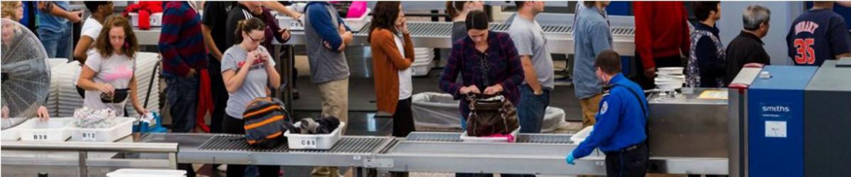
The following items that are banned for carriage on person/hand baggage on board flights operating from civil airports in India; and Indian Registered aircrafts from foreign airports :
 Personal Items
 Sharp Objects
 Sporting Goods
 Guns and Firearms
 Tools
Tools
 Martial Arts / Self Defense Items
 Explosive Materials
 Flammable items
 Disabling Chemicals and other Dangerous Items
Note : The above mentioned are only indicative lists of items. Commonsense, however, shall prevail in assessing whether an object can be used as a weapon for committing any act of unlawful interference with civil aviation operations.
Security related information
Lost and found Baggage
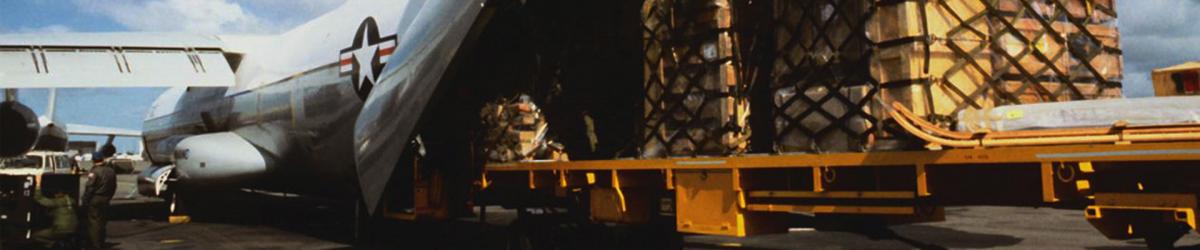
No Separate Cargo Unit is available

| VEIM AD 2.1 AERODROME LOCATION INDICATOR AND NAME |
| VEIM - IMPHAL/ DOMESTIC |
| VEIM | AD 2.2 | AERODROME GEOGRAPHICAL AND ADMINISTRATIVE DATA |
| 1 | ARP coordinates and site at AD | 244551N 0935358E 221.75º/812.5M from THR22 |
| 2 | Direction and Distance from City | 225º,7KM from Imphal city |
| 3 | Elevation/Reference temperature | 2540 FT / 32.0°C |
| 4 | MAG VAR/Annual change | 0.75°W (1985) /0.020E |
| 5 | AD Administration, address, telephone, telefax, telex, AFS | Airports Authority of india, Imphal Airport, Imphal -795140 Tel +91-385-2455138, 2455153 ,09402882763 Fax: +91-385- 2455076 AFS: VEIMYDYX TELEX: NIL |
| 6 | Types of traffic permitted | IFR/VFR |
| 7 | Remarks | Nil |
| VEIM | AD 2.3 | OPERATIONAL HOURS |
| 1 | AD Administration | MON-FRI :0400-1200 UTC (0930-1730 IST) SAT,SUN+HOL : Nil |
| 2 | Customs and immigration | Nil |
| 3 | Health and sanitation | Nil |
| 4 | AIS briefing office | As ATS |
| 5 | ATS reporting office (ARO) | As ATS |
| 6 | MET briefing office | As ATS |
| 7 | ATS | Consult NOTAM For Current ATS HR. |
| 8 | Fueling | As ATS |
| 9 | Handling | As ATS |
| 10 | Security | As ATS |
| 11 | De-icing | NIL |
| 12 | Remarks | Outside of ATS hours services available O/R with 24hr PN to AD. |
| VEIM | AD 2.4 | HANDLING SERVICES AND FACILITIES |
| 1 | Cargo-handling facilities | With Prior Arrangement With Local Airlines |
| 2 | Fuel/Oil types | JET A1 |
| 3 | Fuelling facilities/capacity | 3 Bousers Capacity 11KL,09KL,16 KL each total capaciy 600 KL |
| 4 | De-icing facilities | Nil |
| 5 | Hangar space for visiting aircraft | Nil |
| 6 | Repair facilities for visiting aircraft | Nil |
| 7 | Remarks | Refuelling facility Avbl. at Imphal for Airlines operator.only sector fuel will be provided. |
| VEIM | AD 2.5 | PASSENGER FACILITIES |
| 1 | Hotels | In the City |
| 2 | Restaurants | At AD and in the City |
| 3 | Transportation | Taxi /Car on Hire from AD. |
| 4 | Medical facilities | First aid At AD. Hospitals In City. |
| 5 | Bank and Post Office | Banks: In the city Post office: 0930-1600 IST,except Sun & Holiday. |
| 6 | Tourist office | Avbl 1000-1500 IST except Sun & Holiday |
| 7 | Remarks | Nil |
| VEIM | AD 2.6 | RESCUE AND FIRE FIGHTING SERVICES |
| 1 | AD category for fire fighting | Within AD Hrs:CAT 7 |
| 2 | Rescue equipment | AVBL.as per category. |
| 3 | Capability for removal of disabled aircraft | Nil |
| 4 | Remarks | Nil |
| VEIM | AD 2.7 | SEASONAL AVAILABILITY- CLEARING |
| 1 | Types of Clearing Equipment | Nil |
| 2 | Clearance priorities | Nil |
| 3 | Remarks | Nil |
| VEIM | AD 2.8 | APRONS, TAXIWAYS AND CHECK LOCATIONS DATA |
| 1. | Apron surface and strength | Surface | Concrete |
| Strength | 28/R/B/W/T | ||
| 2. | Taxiway width, surface and strength | Width | 23M |
| Surface | TARMACADAM ( TWY B & D) RIGID ( TWY A &C) | ||
| Strength | --- | ||
| 3. | ACL and elevation | Location | AT APRON |
| Elevation | 2540FT | ||
| 4. | VOR/INS checkpoints | VOR | --- |
| INS | --- | ||
| 5. | Remarks Four parking stand available Stand 1 for ATR 42/ATR 72. Stands 2 &3 for A320 and stand 4 for A300.All Parking Stands are Power-In and Power Out. Limitation & Restriction: 1)The ACFT parked at Stand No. 1 cannot Taxi out when Stand No. 2 is occupied. 2) When Stand No. 1 occupied,ACFT cannot Taxi-in to Stand No. 2.Apron lights for stand 1 and 2 available. Prior approval to be taken before releasing any aircraft due shortage of parking stands. Three aircraft can be parked simultaneously due configuration of parking stands. | ||
| VEIM | AD 2.9 | SURFACE MOVEMENT GUIDANCE AND CONTROL SYSTEM AND MARKINGS |
| 1 | Use of aircraft stand ID signs, TWY guide lines and visual docking/parking guidance system of aircraft stands | Taxiing guidance provided on RTF Guidelines at Apron.. |
| 2 | RWY and TWY markings and LGT | RWY: Marked:Designation,THR,TDZ, Centreline, Edge Rwy End. Lighted: EDGE, Rwy End , THR TWY: Marked:Centerline,Holding Positions Lighted:Edge |
| 3 | Stop bars | Nil |
| 4 | Remarks | Nil |
| VEIM | AD 2.10 | AERODROME OBSTACLES |
|
In approach / TKOF areas |
|||||
|
1 |
2 |
3 |
4 |
5 |
6 |
|
RWY NR/Area affected |
Obstacle type |
Coordinates |
Elevation |
Marking/LGT |
Remarks |
|
APCH-22 TKOF-04 affected |
TREE |
244641.0 N 0935433.2 E |
2611 FT |
NIL |
NIL |
|
APCH-22 TKOF-04 affected |
ELECT.POLE |
244624.7 N 0935419.3 E |
2560 FT |
NIL |
NIL |
|
APCH-22 TKOF-04 affected |
MAST |
244751.1 N 0935613.3 E |
2750 FT |
NIL |
NIL |
|
APCH-04 TKOF-22 affected |
FENCING TOP |
244449.8 N 0935323.6 E |
2543 FT |
NIL |
NIL |
|
APCH-04 TKOF-22 affected |
SOLAR LT ON HILL |
244100.3 N 0935014.7 E |
3120 FT |
LGTD |
NIL |
|
APCH-22 TKOF-04 affected |
TREE |
244623.7 N 0935419.1 E |
2592 FT |
NIL |
NIL |
|
APCH-22 TKOF-04 affected |
TELE.POLE |
244622.5 N 0935417.9 E |
2554 FT |
NIL |
NIL |
| VEIM | AD 2.11 | METEOROLOGICAL INFORMATION PROVIDED |
| 1 | Associated MET Office | Imphal |
| 2 | Hours of service MET Office outside hours | As ATS |
| 3 | Office responsible for TAF preparation period of validity | Guwahati 9HR(00-09) |
| 4 | Trend forecast interval of issuance | NIL |
| 5 | Briefing/consultation provided | Nil |
| 6 | Flight documentation Language(s) used | Tabular Form English |
| 7 | Charts and other information available for briefing and consultation | Nil |
| 8 | Supplementary equipment available for providing information | Nil |
| 9 | ATS units provided with information | Imphal ATC and ACS |
| 10 | Additional information (limitation of service, etc.) | Documents available on request. |
| VEIM | AD 2.12 | PHYSICAL CHARACTERISTICS |
|
Designations RWY NR |
TRUE & MAG BRG |
Dimensions of RWY (M) |
Strength (PCN) and surface of RWY and SWY |
THR coordinates |
THR elevation and highest elevation of TDZ of precision APP RWY (FT) |
|
1 |
2 |
3 |
4 |
5 |
6 |
|
04 |
34.50° GEO 35.50° MAG |
2746 x 45 |
55/F/D/X/T Tarmac |
244457.70N 0935322.10E |
THR:2535.0FT |
|
22 |
214.50° GEO 215.50° MAG |
2746 x 45 |
55/F/D/X/T Tarmac |
244612.30N 0935417.30E |
THR:2540.0FT |
|
Slope of RWY-SWY |
SWY dimensions (M) |
CWY dimensions (M) |
Strip dimensions (M) |
OFZ |
Remarks |
|
7 |
8 |
9 |
10 |
11 |
12 |
|
+ 0.054 |
--- |
|
2866 x 150 |
---- |
Aircraft to make 180 Degree turn at Turning Pad by using turn pad markings to avoid damage to RWY Surface |
|
+0.054 |
--- |
|
2866 x 150 |
---- |
Aircraft to make 180 Degree turn at Turning Pad by using turn pad markings to avoid damage to RWY Surface |
| VEIM | AD 2.13 | DECLARED DISTANCES |
|
RWY designator |
TORA (M) |
TODA (M) |
ASDA (M) |
LDA (M) |
Remarks |
|
1 |
2 |
3 |
4 |
5 |
6 |
|
04 |
2746 |
2746 |
2746 |
2746 |
--- |
|
22 |
2746 |
2746 |
2746 |
2746 |
--- |
| VEIM | AD 2.14 | APPROACH AND RUNWAY LIGHTING |
|
Designations RWY |
APCH LGT TYPE LEN INTST |
THR LGT COLOUR WBAR |
VASIS (MEHT) PAPI |
TDZ, LGT LEN |
RWY centre line LGT Length, spacing, colour and intensity |
RWY edge LGT Length, spacing, colour and intensity |
|
1 |
2 |
3 |
4 |
5 |
6 |
7 |
|
04 |
CAT -I 900M |
Green |
PAPI Left/3.5º MEHT 18.2M |
--- |
--- |
2760M 60M white LIH |
|
22 |
SALS 420M LIH |
Green |
PAPI LEFT/3.2º MEHT 14.4M |
--- |
--- |
2760M 60M white LIH |
|
RWY end LGT colour WBAR |
SWY LGT LEN (M) colors |
Remarks |
|
8 |
9 |
10 |
|
Red |
--- |
--- |
|
Red |
--- |
--- |
| VEIM | AD 2.15 | OTHER LIGHTING, SECONDARY POWER SUPPLY |
| 1 | ABN/IBN Location, characteristics and hours of operation | IBN : Nil ABN : At Tower Building,FLG W&G EV2SEC As ATS HR |
| 2 | LDI location and LGT Anemometer location and LGT | LDI: Lighted,NE corner of Apron Anemometer: On TWR Bldg,Lighted |
| 3 | TWY edge and centre line lighting | Center line: ----- Edge: All Twy except TWY 'A' |
| 4 | Secondary power supply/switch-over time | Secondary Power supply to all lighting at AD. Switch-over time : 30 SEC. |
| 5 | Remarks | WDI Lighted |
| VEIM | AD 2.16 | HELICOPTER LANDING AREA |
|
Not Established |
| VEIM | AD 2.17 | ATS AIRSPACE |
| 1 | Designation and lateral limits |
Imphal CTR.Bounded by 250002N 0932548E 245902N 0933048E, Then along circle of radius 46.3km(25NM) centered at "IIM" VOR 244529N 0935352E to 243902N 0932748E Then along a shorter arc of The circle of radius 46.3km (25NM) centered At "KKU" VOR 245449N 0925839E to 250002N 0932548E. |
| 2 | Vertical limits | SFC TO FL200. |
| 3 | Airspace classification | D |
| 4 | ATS unit call sign Language(s) |
Imphal Tower. English |
| 5 | Transition altitude | 11,000FT |
| 6 | Remarks | NIL |
| VEIM | AD 2.18 | ATS COMMUNICATION FACILITIES |
|
Service designation |
Call sign |
Frequency |
Hours of operation |
Remarks |
|
1 |
2 |
3 |
4 |
5 |
|
TWR |
Imphal Tower |
124.35 MHZ |
As ATS HR |
SMC,TWR and APP services combined. |
|
ATIS |
Imphal Information |
126.65 MHZ |
|
|
| VEIM | AD 2.19 | RADIO NAVIGATION AND LANDING AIDS |
|
Type of aid CAT of ILS/MLS (For VOR/ILS/MLS, give VAR) |
ID |
Frequency |
Hours of operation |
Site of transmitting antenna |
ELEV of DME transmitting antenna |
Remarks |
|
1 |
2 |
3 |
4 |
5 |
6 |
7 |
|
NDB |
IM |
289.0 kHz |
As ATS HR |
244529.4 N 0935320.7 E |
--- |
|
|
LLZ 04 |
IIPH |
110.3 MHz |
As ATS HR |
244621.4 N 0935425.0 E |
--- |
ILS CAT I |
|
GP 04 |
- |
335.0 MHz |
As ATS HR |
244503.6 N 0935331.4 E |
--- |
3.5°,RDH 58FT |
|
DME (DVOR) |
IIM |
1130/1193MHz |
AS ATS HR |
244529.4N 0935351.8E |
--- |
--- |
|
DME ( ILS) |
IIPH |
1064/1001MHz |
AS ATS HR |
244503.6N 0935331.4E |
2549FT |
Collocated with GP04 |
|
DVOR |
IIM |
115.900MHz |
AS ATS HR |
244529.4N 0935351.8E |
2560FT |
|
| VEIM | AD 2.20 | LOCAL TRAFFIC REGULATIONS |
|
----------------------- |
| VEIM | AD 2.21 | NOISE ABATEMENT PROCEDURES |
|
----------------------- |
| VEIM | AD 2.22 | FLIGHT PROCEDURES |
| STANDARD INSTRUMENT DEPARTURE PROCEDURES | ||
| 1 | Standard Instrument Departures Procedures (SIDs) for Imphal have been developed for both Runways (RWY 04 and RWY 22). | |
| 2 | SIDs provide the track guidance upto interception of ATS route along with required obstacle clearance and thus eliminate the requirement of aircraft to climb over the VOR upto MSA before establishing on desired track. | |
| 3 | Due to the high terrain the minimum climb gradient of 7% (425 FT/NM) has been specified as Procedure Design Gradient (PDG) until passing 8500 feet for all the SIDs. | |
| 4 | The minimum climb gradient of 3.3% (200 FT/NM) may be maintained after passing 8500 feet. | |
| 5 | Speed restrictions have been specified with each SID wherever applicable. | |
| 6 | Altitude restrictions at the VOR/DME fix have been specified wherever necessary. | |
| 7 | All the radials and distances have been specified from Imphal VOR/DME (115.9 IIM). | |
| 8 | Any altitude restriction by ATC shall be imposed only after departing aircraft has reached the applicable minimum sector altitude (9500 ft or 11000 ft). | |
| 9 | Aircraft unable to follow the SIDs, shall inform ATC and request for alternate clearance. |
| SIDs Runway 04 - Imphal | |||||
|
Sl. No. |
ATS Route |
SID Name |
Description |
Remarks |
|
|
i
|
W55 (R-280) |
Silchar 1 |
Climb straight ahead. Passing 3000 feet, establish R035. At 5.5 DME turn left to establish R350 for Cat C and R005 for Cat A/B to VOR. At 1.0 DME (R350/R005) turn right heading 310 to establish R280 to join W55 outbound.Cross R035/5.5 DME at or above 4500 ft & 1DME (R350/R005) at or above 8100 ft. |
For Cat C speed restricted to 204 KT IAS maximum until interception of R350. |
|
| ii |
W54 (R-251) |
Agartala 1 |
Climb straight ahead. Passing 3000 feet, establish R035. At 5.5 DME turn left to establish R350 for Cat C and R005 for Cat A/B to VOR. At 1.0 DME (R350/R005) turn right to establish R251 to join W54 outbound.Cross R035/5.5DME at or above 4500 ft & 1DME (R350/005) at or above 8100 ft. |
For Cat C speed restricted to 204KT IAS maximum until interception of R350. |
|
| iii |
W83 (R-232) |
Lengpui 1 |
Climb straight ahead. Passing 3000 feet, establish R035. At 5.5 DME turn left to establish R350 for Cat C and R005 for Cat A/B to VOR. At 1.0 DME (R350/R005) turn right to establish R232 to join W83 outbound. Cross R035/5.5DME at or above 4500 ft & 1DME (R350/R005) at or above 8100 ft. |
For Cat C speed restricted to 204KT IAS maximum until interception of R350.
|
|
| iv |
W55 (R-355) |
Dimapur 1 |
Climb straight ahead. Passing 3000 feet, establish R035. At 14 DME turn left to intercept 16 DME arc and then establish R355 to join W55 outbound. Cross R035/14 DME at or above 8100 ft. |
||
| SIDs Runway 22 - Imphal | ||||
| S.No |
ATS ROUTE |
SID NAME |
DESCRIPTION |
REMARKS |
| i |
W55 (R-280) |
Silchar 2 |
Climb straight ahead. Passing 3000 feet turn left to establish R200. At 8DME turn right to intercept 10DME arc and then establish R280 to join W55 outbound.Cross R200/08DME at or above 5600 ft. |
|
| ii |
W54 (R-251) |
Agartala 2 |
Climb straight ahead. Passing 3000 feet turn left to establish R200. At 8DME turn right to intercept 10 DME arc then establish R251 to join W54 outbound.Cross R200/08 DME at or above 5600 ft. |
|
| iii |
W83 (R-232) |
Lengpui 2 |
Climb straight ahead. Passing 3000 feet turn left to establish R200. At 13 DME turn right to intercept 15DME arc. Then establish R232 to join W83 outbound.Cross R200/13DME at or above 7700 ft. |
|
| iv |
W55 (R-355) |
Dimapur2 |
Climb straight ahead. Passing 3000 feet to establish R215. At 5 DME turn left to establish R170 for Cat C & R185 for Cat A/B to VOR. Then proceed via R010 and passing 9000 feet turn left to establish R355 to join W55 outbound.Cross R215/05DME at or above 4300 ft & VOR at or above 8300ft. |
1. For Cat C speed restricted to 204 KT IAS maximum until interception of R170. 2.Aircraft able to climb to 9000ft or above before reaching VOR may proceed directly via R355 |
| VEIM | AD 2.23 | ADDITIONAL INFORMATION |
|
TWY DESIGNATOR |
REMARKS |
|
A |
Link TWY between RWY and NCC hanger towards beginning of RWY22. |
|
B |
Link TWY between RWY and main Apron towards RWY 22 and ARP. |
|
C |
Link TWY between RWY and main Apron towards Fire station. |
|
D |
Link TWY between RWY and Isolation bay towards beginning of Fire station. |
| VEIM | AD 2.24 | CHARTS RELATED TO AN AERODROME |
| 1. | ILS RWY 04 | |
| 2. | VOR RWY 04 | |
| 3 | Non-RNAV SID |

Airports Authority of India,
Rajiv Gandhi Bhawan,
Safdarjung Airport,
New Delhi-110003
Ph : 91-11-24632950


